Services
Thanks to our fleet of specialized drones, we can meet all your needs in:
-
Volumetrics and precision mapping
-
Technical inspection and 2D/3D modeling
-
Photogrammetry and aerial cinematography
-
Nighttime projects and projects in complex conditions
Our services cover the industrial, municipal, environmental and mining sectors, throughout Quebec and Canada.
Certified expertise and regulatory compliance
All our pilots hold an advanced drone pilot license issued by Transport Canada, ensuring safe and compliant operations.
We also have a level 1 certified thermographer, on track to obtain level 2 certification in October, for accurate and reliable thermal analyses.
Rapid study, planning and submission
Each project begins with a personalized analysis, including:
-
Technical and feasibility study
-
Operations planning
-
Detailed cost estimate
We will provide you with a clear and prompt quote, tailored to your specific needs.
Would you like me to help you structure this section in JSON-LD for SEO, or translate it into English for your bilingual site? I can also help you write the other sections (home, services, about, etc.) with the same rigor.
Volumetric Service
Volumetrics: Precise and compliant measurements
We perform high-precision volumetric measurements using drones equipped with high-resolution sensors and specialized software. This technology allows us to quickly and efficiently quantify the volumes of materials or land, while ensuring rigorous traceability.
Our services are particularly suited to the following environments:
-
Construction sites
-
Mining sites and quarries
-
Earthmoving operations
-
Industrial and port areas
Advantages of our approach
-
Accuracy: Reliable results thanks to cutting-edge technology and rigorous protocols.
-
Efficiency: Reduction of manual labor, delays and risks of human error.
-
Compliance: Adherence to quality control standards and regulatory requirements.


Thermographic inspection
Thermography: High-precision thermal analysis
Aerial thermography is an advanced technology used to detect temperature variations on the surface of buildings, land, or equipment. Using an onboard thermal camera, our drones capture infrared radiation invisible to the naked eye, revealing anomalies undetectable by conventional visual inspection.
Practical applications
-
Building inspection: detection of air leaks, insulation defects, water infiltration
-
Industrial monitoring: control of solar panels, power lines, sensitive equipment
-
Search and rescue: locating people by their thermal signature
-
Precision agriculture: monitoring crop health, detecting water stress
Advantages of drone thermography
-
Fast and secure analysis, without interrupting operations
-
Access to difficult or dangerous areas, without scaffolding or human intervention
-
Precise visualization of thermal anomalies, with supporting technical report
Structural inspection of all kinds
Technical inspection: High resolution and safety
Thanks to our advanced drone technology, we perform high-resolution visual inspections on structures of all sizes, including:
-
Bridges and viaducts
-
Industrial and commercial buildings
-
Pipelines and linear infrastructure
-
Sensitive or hard-to-reach installations
Our drones capture images of exceptional clarity, enabling detailed and precise analysis without interrupting operations.
Structural analysis and preventive planning
The data collected is:
-
Analyzed by our qualified engineers
-
Or transmitted to an external firm according to your preferences
This analysis allows us to:
-
Identify the structural problems
-
Identify the risk areas
-
Plan preventive and targeted interventions
Advantages of drone inspection
-
Fast execution, even on complex sites
-
Increased safety, without endangering staff
-
Reduced interruptions, compared to traditional methods
Trust Drone-Exploration for cutting-edge inspection solutions designed to ensure the sustainability, compliance, and safety of your infrastructure.


Photogrammetry
Photogrammetry and 3D Modeling precision
Photogrammetry is an advanced technique used to determine the volumes, dimensions, and geometries of a structure from aerial or ground-based photographs. These images are analyzed by specialized algorithms, which reconstruct a 3D digital relief model of the scanned area.
Modeling process
We use drone and ground-based photogrammetry to produce complete 3D models, including:
-
High-resolution image capture
-
3D reconstruction using algorithms
-
Realistic mesh and texturing
The resulting image is ideal for:
-
-
Project presentations
-
Digitization of claims (accidents, fires, etc.)
-
Creation of technical plans
-
Support for renovation projects
-
Integration of future works into the existing environment
Compatibility with your tools
The generated files can be easily integrated into your professional software, such as:
-
AutoCAD
-
ArcMap
-
Autodesk
-
QGIS
-
And other GIS or CAD platforms
-
Inspection during construction work
Ongoing work inspection – Active and continuous monitoring
For projects requiring constant supervision, Drone-Exploration offers on-the-job inspection services tailored to industrial, municipal and construction environments.
We conduct regular inspections throughout the process to ensure that the work meets technical standards, contractual specifications and quality requirements.
Final inspection and validation of results
Once the work is completed, we carry out a full final inspection, allowing us to:
-
Check the quality of the work
-
Confirm compliance with plans and standards
-
Document the results for your reports or audits
Advantages of active monitoring
-
Early detection of anomalies and deviations
-
Quick fix before a problem becomes critical
-
Reducing risks and costs associated with takeovers
-
Peace of mind thanks to continuous and professional supervision
With Drone-Exploration, you benefit from rigorous and secure monitoring throughout your projects, for flawless execution and lasting results.

Inspection of riverbanks and conservation infrastructure
Territorial surveillance
Quick and travel-free inspection
Thanks to our fleet of long-range drones, we carry out surveillance missions over very large areas, allowing us to cover a vast territory in a short time, without requiring additional ground travel.
This service is ideal for remote, large or hard-to-reach areas, where speed of intervention and accuracy are essential.
Access to complex areas and targeted inspection
Our drones are particularly effective for:
-
Inspect riverbanks, rivers and wetlands
-
Monitor conservation infrastructure and isolated structures
-
Accessing steep, wooded or vehicle-inaccessible terrain
Each mission is planned to ensure comprehensive coverage, high-resolution visual documentation, and reliable technical analysis.

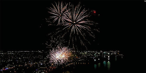
Events of all kinds
Aerial event recording
High-definition images and sound
Whether it's for a running race, a cycling race or a mountain biking race, a public event, an outdoor show, fireworks or any other outdoor event, Drone-Exploration offers partial or complete aerial capture.
Our drones allow us to produce spectacular images, while also capturing ambient sound for total immersion.
Highlighting your events
-
Dynamic aerial view for your promotional videos
-
Real-time or delayed tracking, depending on your needs.
-
Synchronized sound recording for faithful reproduction
-
Editing on request or raw file delivery
👉 See the videos in the Portfolio section to discover our recent projects

Search and rescue
Search for missing persons
Air support by drone
Drone-Exploration can participate in search and rescue missions for missing persons, in collaboration with:
-
The Sûreté du Québec
-
Fire services
-
The municipal police forces of the region
Our drones enable rapid coverage of vast territories, including wooded, isolated or hard-to-reach areas, while providing real-time aerial views and thermal detection when conditions permit.
This service is offered as part of official operations, in support of the competent authorities, to accelerate searches and optimize resources on the ground.