
Our achievements
Demonstration projects
Discover here a selection of completed projects, illustrated by videos and photos captured by Drone-Exploration. These demonstrations highlight our expertise in technical aerial imaging.
Ski Gallix Mandate 2024 and evolution 2025
The first project completed in 2024 for Ski Gallix served as the basis for a new approach in 2025: field monitoring. This innovative method allows for sharper images, better visual quality, and a more precise interpretation of the terrain.
Thanks to this development, we improve the technical value of the data delivered while strengthening its operational usefulness for our customers.

Nighttime 3D modeling; Snow sculpture winner of BlizzArt 2024
Discover the 3D modeling video of the snow sculpture that won the 2024 edition of the BlizzArt festival.
Captured at night, this operation presented a major technical challenge, both for image capture and data processing. Thanks to rigorous planning and Drone-Exploration's expertise, the result lives up to expectations: a faithful, precise, and immersive rendering of the ephemeral artwork.
A powerful demonstration of our ability to deliver high-quality results, even in complex conditions.
3D Modeling
Gallix ski resort – Technical project covering 4 km²
Drone-Exploration completed a full 3D model of the Gallix ski resort, covering an area of 4 km², in just two field trips. This ambitious project marked a turning point in our approach, reinforcing our enthusiasm for complex and large-scale projects.
Despite the regulatory constraints of Transport Canada, sometimes demanding in mountainous areas, rigorous preparation and technical mastery enabled us to deliver accurate and compliant results.
At Drone-Exploration, we believe that nothing is impossible with good planning

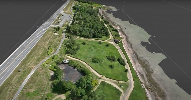
3D scan of the Jardin de l'Anse Park
Sept-Îles Drone-Exploration carried out a 3D scan of the Jardin de l'Anse Park in Sept-Îles as part of a test mandate aimed at validating the effectiveness of our GNSS base.
This project, although modest in scope, has demonstrated the precision and reliability of this indispensable tool, now integrated into our standard equipment.
Thanks to the GNSS base, we obtain high-precision geospatial data, essential for modelling, mapping and technical inspection projects.
The scan video perfectly illustrates our ability to deliver professional results, even in experimental settings.
Technical inspection without lifting equipment
Security, efficiency and continuity
Thanks to aerial drone imaging, Drone-Exploration carries out technical inspections without using lifting equipment such as platforms or scaffolding.
This approach makes it possible to considerably reduce the use of “spidermen”, whose profession is admirable but involves high risks.
A major advantage for rolling stock:
Inspections can be carried out with a very short technical shutdown, or even without any interruption at all, resulting in a significant reduction in production losses.
Infrared thermography. Advanced thermal analysis.
Drone thermography offers valuable solutions for:
-
Detecting water leaks in buildings
-
Identify overheating of moving or electrical parts
-
Conducting accurate energy audits
Technology at the service of security, performance and profitability


